Homeland Security

Image Description

Unrivaled performance 

Small tactical unmanned aircraft is an excellent choice for cost-effective ISR missions.This aircraft is optimized for gyro-stabilized day and night payloads with under 2 kg (4.5 lb) weight, the endurance of up to 20 hours, and radio link range of 100 km. The aircraft MTOW is 23 kg (50.7 lb).

Image Description

Tailored for military use 


APPRO drones military configuration of the tactical series aircraft is tailored specifically for military use and applications.

Additional features such as artillery fire control functionality, advanced datalinks, anti-jamming features, and state of the art day and night payloads are available. All UAV Factory solutions are NON-ITAR. 

Features

ISR missions

ISR missions require the ability to track targets of interest for extended periods of time while remaining undetected. Small tactical unmanned aircraft have proven to be a valuable tool for ISR missions around…

Artillery fire control

Small tactical unmanned aircraft are highly suitable for the performing artillery fire correction function. In this application unmanned aircraft equipped with gyro-stabilized EO/IR payload provides information…

Image Description

Utilities inspection with the APPRO 

APPRO can survey up to 100KM of power lines or water pipes or up 1000ha of solar panels in a single flight, and monitor remote sites up to 50KM distance, using high resolution Thermal and RGB video. It does this fully autonomous and can fly predefined corridors with automatic terrain following.

✔ Inspect power lines and isolators
✔ Thermal monitoring of solar panels
✔ Identify potential hazards to underground pipelines
✔ Locate water leaks

APPRO records both Thermal and RGB video feeds simultaneously with embedded geo-coordinates. It can fly long distances, even beyond radio range. The recorded videos are easily retrieved from the onboard sd-cards and can be reviewed and analyzed i great detail. 

Image Description

Orthomosaic & 3D mapping with the APPRO Drones

Aerial intelligence with CM level accuracy for planning, construction and maintenance of utilities.

✔ Plan and prepare pole construction with CM level accurate orthomosaic maps
✔ Digitize power grids with 3D point clouds
✔ Monitor and report on construction progress
✔ Map road access conditions and assess construction costs
✔ Monitor erosion, ground displacement and vegetation activities

APPRO Drones provides high resolution imagery combined with CM level accuracy geo-referencing to produce highly accurate orthomosaic maps, 3D models and Digital Surface Models. Using terrain following corridor scans and automatically generated area surveys APPRO Drones make aerial data collection effortless and easy to obtain.

Image Description

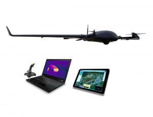
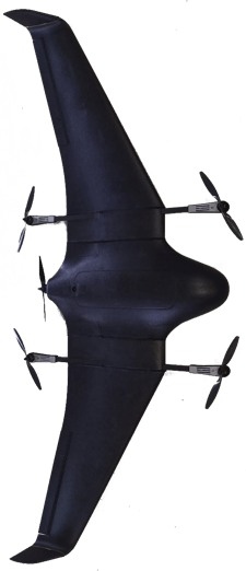
Live thermal and RGB video with the APPRO Drones

APPRO Drones provide live Thermal and HD RGB video for aerial reconnaissance of remote sites. With up to 30KM video range, or unlimited range using the mobile network.

✔ Live HD video of hard to reach areas
✔ Actionable intelligence for emergencies and natural disasters
✔ Live reconnaissance of breakage or spills
✔ Improve employee safety with aerial reconnaissance in dangerous areas

APPRO Drone provide joystick control of both High Definition and Thermal video live from a stabilized camera gimbal. While the vehicle flies fully autonomous, or guided to areas of interest, a camera operator can move, zoom in and automatically track objects. The video is streamed securely to the ground and recorded on board for post analysis.

DEFENSE

UAV Factory provides militaries around the world with long-endurance, long-range, mobile unmanned aircraft system solutions for intelligence, surveillance, and reconnaissance (ISR) missions.
The aircraft systems are non-ITAR restricted, giving our global customers easy access to their capabilities. 

More endurance

The DeltaQuad can fly almost 2 hours with distances up to 100km carrying payloads up to 1Kg

Vertical Takeoff and Landing

It can takeoff and land in confined areas of 5x5 meters or more

Advanced safety features

Automated pre-flight and inflight checks with failsafe fallback procedures

Deploy in minutes

Tool-less 1 minute deployment and no pre-flight calibrations

Fully autonomous

Fully autonomous missions from takeoff to landing, even beyond communication range

Simple mission planning

Plan your missions easily with touch screen satellite maps and automatic path generation

Ready to start your mission?

We offer full service from planning to execution for all your needs

APPRO

Create drones with high end technology...

+90 (212) 356 2828

info@appro.com.tr

Istanbul/Turkey