Plan, Inspect, Deliver

UAV Solutions for Oil & Gas

Image Description

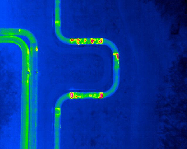
Pipeline inspection and remote monitoring 

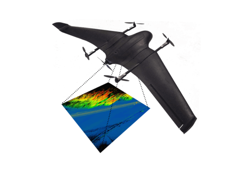
APPRO can survey up to 100KM of pipeline, and monitor remote sites at up to 50KM distance, using high resolution Thermal and RGB video. It does this fully autonomous and can fly predefined corridors with automatic terrain following.

✔ Detect pipeline defects, leaks, corrosion or frost heave
✔ Monitor remote, offshore or isolated sites
✔ Identify potential hazards to underground pipelines
✔ Monitor Right Of Way environments

APPRO records both Thermal and RGB video feeds simultaneously with embedded geo-coordinates. It can fly long distances, even beyond radio range. The recorded videos are easily retrieved from the onboard sd-cards and can be reviewed and analyzed in great detail.

Image Description

Orthomosaic & 3D mapping 

Aerial intelligence with CM level accuracy for planning, construction and maintenance of Oil & Gas transport and production sites.

✔ Plan and prepare trench digging or construction sites
✔ Monitor and report on pipe laying progress
✔ Manage and digitize inventory for construction, redevelopment or decommissioning
✔ Map road access conditions and access construction costs
✔ Prepare and optimize rig or platform moves
✔ Monitor erosion, ground displacement and vegetation activities
✔ Detect Hydrocarbon seeps and prospect areas for Oil & Gas

APPRO provides high resolution imagery combined with CM level accuracy geo-referencing to produce highly accurate orthomosaic maps, 3D models and Digital Surface Models. Using terrain following corridor scans and automatically generated area surveys the APPRO makes aerial data collection effortless and easy to obtain.

More endurance

The DeltaQuad can fly almost 2 hours with distances up to 100km carrying payloads up to 1Kg

Vertical Takeoff and Landing

It can takeoff and land in confined areas of 5x5 meters or more

Advanced safety features

Automated pre-flight and inflight checks with failsafe fallback procedures

Fully autonomous

Fully autonomous missions from takeoff to landing, even beyond communication range

Automatic terrain following

Plan missions with automatic terrain following across hills, valleys and mountains

Radio and/or mobile internet

Up to 30KM radio range or unlimited using the mobile network

Would you like to know more?

Want to know more about optimizing your business with our autonomous VTOL drones? We are happy to discuss your project and advise on possibilities and deployment. From a single unit to a managed fleet you can speak directly to our specialists without any obligations.

APPRO Drone

Auto Route

APPRO Drones follow routes that you created. 

Easy to use

with a few hours training is enough to fly...

Thermal Image

the most effective way to detect leaks...

WHO WE ARE

Benefits of UAV’s (Drones)

Provides a fast and autonomous solution for both security and leakage control of long distance oil, gas and water pipelines.

Autonomous

Auto take off/landing and follow routes

Speed & Cost Saving

just 1 drone can control thousands km of pipeline

High End Sensors

Lidar, thermal sensors detect ground and make your project more reliable

Remote monitoring and collaboration

Through the Internet connection, the remote pilot can fully operate and monitor the flight platform for flight missions

Synchronous webcast

The video imaging collected by aircraft are transmitted to the remote
command center through Internet streaming technology, live broadcast
the situation on the front line, and provide instant information reference
for the command work

Target vision follow

According to the real-time imaging streamed by the EO, you can directly click on the vehicle, building, and location in the screen to control, so that the aircraft can reach the target location and continue to monitor

Routine planning

A single route can plan up to 1,800 way points, adapting to
various complex terrain and airspace environments.

APPRO

Create drones with high end technology...

+90 (212) 356 2828

info@appro.com.tr

Istanbul/Turkey